An account by Ted Croucher, Local Historian and Pease Pottage resident
Pease Pottage is the first place of significance after Balham (Gateway to the South) on the London Brighton road, now known affectionately as the A23 (M23). Pease Pottage is featured in the film “Genevieve”, and Melanie Jane Bush lived at 36 Down View before joining Dr. Who.
The unusual name is reputed to come from travellers from London to Brighton stopping for some refreshing pea soup at the gate to the forest (the old name is Peas Pottage Gate), but the name dates back much earlier than George III who put Brighthelmstone on the map, and the Brighton Road did not exist in those days. It was also reputed to be used by prisoners commuting between East Grinstead and Horsham Goals, but that seems equally unlikely. According to ‘A Dictionary of English Place-Names, Oxford University Press, A.D. Mills, 1998’ it was recorded as Peaspottage Gate in 1724, and was probably a reference to soft muddy ground.
In fact Pease Pottage as a site is extremely old as it was first occupied in Mesolithic times soon after the end of the last ice age. The Horsham Culture developed a particular type of flint tool – a microlith called the Horsham Point. The area is called the High Weald (from the German Wald or wood), and formed a relatively dry ‘island’ between the two arms of the wet Low Weald to the north and south. The flints were probably mined in the South Downs, and were finished locally – there are at least two local sites, one along Parish Lane, and the other in Southgate. Neolithic flints have also been found, and a Bronze Age trackway runs from East Grinstead to Horsham along the ridge through Pease Pottage, with the banks still just visible if you know where to look, and also some burial mounds. (The obvious line of this trackway is along Parish Lane, but this gets very wet in winter to the east of the modern railwayline, and a winter route would probably run to the south along the road called High Street between Handcross and Worth Abbey.) This trackway was still in use in Roman times, and as iron was mined just to the south it was possible that the area was occupied in the Iron Age.
In Saxon times Pease Pottage was on the frontier between the South Saxons on the south coast (Sussex), and the Middle Saxons to the north (Surrey being the southern area of Middlesex). The South Saxons moved north into the forest know as Andreaswald, forming settlements at Lower Beeding and Slaugham while the Middle Saxons moved south to settle at Langley. However the border was not clearly defined with Hazelwick and Gatwick (to the north) having connections with Washington in the south, and Shelley in the south was part of Crawley to the north. By late Anglo-Saxon times, Sussex was divided with Pease Pottage on the border of the Bramber and Lewes. They were subdivided into hundreds with the Hundred of Burbeach to the west and the Hundred of Buttinghill to the east. Each hundred was subdivided into vills, with Pease Pottage on the boundary of Ifield, Worth and Slaugham. Prior to Norman times Worth was part of the Hundred of Churchfelle which was in Surrey (see the Doomsday Book), but soon after it became part of the Hundred of Buttinghill (William de Warrenne became Earl of Surrey and took over control of Worth Forest, but he was also Lord of Lewes and had most of his land in Sussex). This change in a major border indicates that the region was only sparsely settled.
The Normans created a royal hunting reserve in St.Leonards Forest (strictly a chase rather than a forest because it was not subject to forest laws), and it is assumed that the names ending with gate (Peas Pottage Gate, Faygate, Colgate, Monks Gate etc) were entrances. However later on in the 1700’s there was a tollgate at Pease Pottage and Gate was dropped from its name when it was removed in 1877. The name Pease Pottage Gate appears on Budgen’s map of 1724 which preceeds the toll road. (Tilgate however was an entrance to Worth Forest.)
The forest is reputedly named after a French knight who killed the last dragon in England. Today this forest is very fragmented, and all that is left of the Pease Pottage Forest is in the centre of the M23 roundabout.
In the mid 16th century the Worth Forest Foundary at Cinderbanks (where Parish Lane crosses the railway line) was being used to cast cannons. This was owned for a time by Thomas Seymour who wanted to build a new town in the forest, but he was executed first (in 1549). Apart from the iron industry little is known of Pease Pottage. The main route to Brighton was further east (in 1756 the London Brighton stage coach went via East Grinstead and Lewes). A toll road from Crawley north to London was built in the early 18th century, but the road south to Brighton through Pease Pottage was not constructed until 1770, and in 1797 there were two coaches a day in each direction. Prior to this most roads were impassible except in dry spells with the exception of the east-west ridgeway which is clearly marked on Budgen’s map of 1724 (which shows the road south from the north terminating at Pease Pottage Gate). Thus it was very likely that there was little at Pease Pottage prior to the opening of the tollroad, but then it would be at an important crossroads.
In Recollections of Henry Burstow he states that on 5 October 1824 he went to Peas Pottage to see Queen Victoria pass through on her way from London to Brighton. There was “a large archway made of evergreens, with VICTORIA REGINA worked on it in various coloured dahlias”.
The Ridgeway (today known as Horsham Road and Forest Road) was turnpiked in 1771 being the main Horsham-Crawley road prior to the McAdam Road being built in 1823 (now the old route of the A264 – it would have been extremely wet before it was given a hard surface).
William Cobbett travelled the ridgeway on 31st July 1823.
“…CRAWLEY…go two miles along the road…to Brighton; then you turn to the right [at Pease Pottage] and go over six of the worst miles in England…The first two of these miserable miles go though Buchan Hill, the estate of Lord ERSKINE [Lord Chancellor]. It was a bare heath here and there, in the better parts of it, some scrubby birch. It has been, in part, planted with fir-trees, which are as ugly as the heath was; and, in short, it is a most villanous track.” This extract from the Rural Rides show that it hasn’t changed much in the last 180 years (apart from our definitions of villanous and beautiful), except that fields have extended from Shelley Plain to the south up to the ridgeway, while Cottesmore Golf Course is on the nothern slopes. But a walk through the woods immediately south of Forest Road or around Buchan Country Park still gives a good idea of what is was like. However one change that Cobbett would notice is the invasion of that indestructible weed, Rhododendron, which is rapidly taking over the woods.
The original house at Buchan Hill was built in the early 1800s by Hon. Thomas Erskine (later Lord Chancellor). His father was the Earl of Buchan, from which it may have taken its name although Buchan Hill is named on Richard Budgen’s map of 1724.
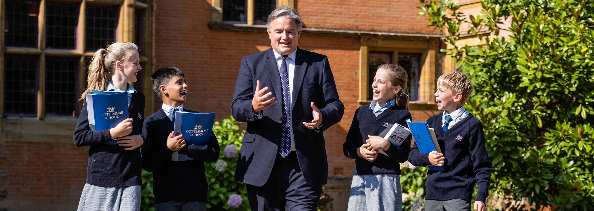
The new Buchan Hill was built in 1883 by Philip Feril Renault Saillard who made his money in ostrich feathers. It cost £40000 – a lot in those days. It was designed by the London partnership George and Peto, and Sir Edward Lutyens worked on the architectural and structural drawings. The house was put up for sale on Saillards death and after five years was bought by Upland House School. One of the masters was Michael Rogerson who left to run Cottesmore School in Hove. Two of Saillards grandsons attended Cottesmore and the Hove school was designed by George. Buchan House was occupied by the Pearl Assurance Company during the war, but when they left in 1946 Michael Rogerson bought it together with the farm. Cottesmore School moved in and have been there ever since.
Pease Pottage is on the on the edge of St Leonards forest. I came across an interesting reference to it at “http://www.biblebelievers.org.au” (the document is no more) to it in a document entitled Living Dinosaurs from Anglo-Saxon and other Early Records by Bill Cooper. The extract (August 1614) reads:
“This serpent (or dragon as some call it) is reputed to be nine feete, or rather more, in length, and shaped almost in the form of an axletree of a cart; a quantitie of thickness in the middest, and somewhat smaller at both endes. The former part, which he shootes forth as a neck, is supposed to be an elle long; with a white ring, as it were, of scales about it. The scales along his back seem to be blackish, and so much as is discovered under his bellie, appeareth to be red . . . it is likewise discovered to have large feete, but the eye may be deceived, for some suppose that serpents have no feete. . . rids aways(as we call it) as fast as man can run. His food is thought to be for the most part in a conniewarren, which he much frequents… There are likewise upon either side of him discovered two great buches so big as a large foote-ball, and (as some think) will in time grow to wings, but God, I hope, will (to defend the poor people in the neighbourhood) that he shall be destroyed before he grows to fledge. The dragon was seen by John Steele, Christopher Holder, a certain widow women dwelling neare Faygate, and the carrier of Horsham, who lieth at the White Horse in Southwark. “
This is plainly false because as all locals know, the last dragon in England was killed in the forest by St. Leonard nearby, many centuries earlier, the evidence being the lilies-of-the-valley which are found where drops of its blood fell.
In 1825 Gideon Mantell, a physician living in Lewes published his “Notice on the Iguanodon, a Newly Discovered Fossil Reptile, from the Sandstone of Tilgate Forest, in Sussex,” based on several teeth and some leg bones. The fossils were found by his wife at Whitemans Green near Cuckfield, and thought to be similar to iguana (the pacific dragon), but some twenty times larger. However Iguanodons died out some 120 million year’s ago so could not be St Leonard’s dragon.
The London, Brighton and South Coast railway completed in 1841 skirted along the eastern boundary of Pease Pottage cutting through Tilgate Forest.
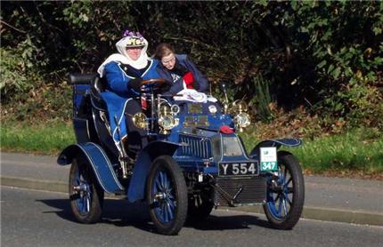
In 1896 on the day after the red flag law expired, 25 cars left London for Brighton, but half had broken down by Pease Pottage. This event is still celebrated in the Veteran Car Run which still goes past Pease Pottage on the first Sunday in November.
There was a large army camp on the Horsham Road at the start of the First World War.
The green in front of the Black Swan in the centre of the village was like a fairground with charabancs parked, stalls, flower sellers, strolling players etc. between the wars. The pub dates back to the 19th century. There was a shop and a Jet petrol station opposite, with the Busy Bee resturant behind (now the M.23 cutting). The Grapes is further south, and had a tin church next to it. It was originally a toll house, and the name came from grapes growing in a greenhouse.
To the south of Pease Pottage is Tilgate Forest Row which had three shops, a blacksmith and post office. The Pease Pottage Cricket Field was between here and Pease Pottage . The cricket field was made in 1874, but was ploughed up in 1939 as part of the war effort. It had a London horse-drawn tram as a pavilion. The ground was up to county ground standards.
A village sign, two deer grazing in the forest, was erected on what is left of the village green in 1977. The Black Swan was called the James King for many years (after the brewers King and Barnes), but the brewery was taken over by Badger, and the pub returned to its original name of the Black Swan when it reopened in 2001 following a face lift.
Pease Pottage is on either side of the A23, but the M23 opened in 1975, the southern end blending into the southern A23 which continued as a two lane dual carriage way to Handcross. The northern A23 to Crawley and the ridge route through Pease Pottage (Horsham Road) were connected to it via sliproads from a high level roundabout. There was a northbound sliproad from the A23 into the centre of Pease Pottage. The old northbound A23 became a cul-de-sac (Old Brighton Road North). The southbound A23 was rebuilt as a three lane dual carriageway in the early 1990’s slightly west of the old route, the northbound sliproad closed, and the southbound lane of the old A23 became Brighton Road to Handcross (numbered as the B2114 from the new southbound A23 exit south of Tilgate Forest Row), a small roundabout being constructed at its junction with Horsham Road/Parish Lane. A foot bridge crossing eight lanes of traffic was built to connect Brighton Road and Tilgate Forest Row with a new road (called Old Brighton Road South) linking Pease Pottage centre to Woodhurst (this road is missing from the 1997 Explorer 134 Ordnance Survey Map which still shows the old sliproad).
Woodhurst was constructed as a Country House in the early 1800’s. It has an interesting history having been owned by Dame Margot Fonteyn and used as a ballet school. During World War 2 it was occupied by the Canadian army and was later used by the NHS as Woodhurst Hospital, and later 55 older people with learning difficulties living in residential care provided by Surrey Oaklands NHS Trust. This closed in 2003, and the site is being developed for multiple private occupation.
Pease Pottage Service Station was built about 1990 and provides the only shop in Pease Pottage apart from the florist. A special footpath was built into the service area for pedestrians from Pease Pottage. A new Marks and Spencer Simply Food was added to the service station in 2007.
Pease Pottage is within an ‘Area of Outstanding Natural Beauty’.